
Michigan Public Policy Survey - Regions of Michigan
Michigan is a large state with significant geographic diversity. Different regions of the state have varying economic bases, varying demographic and cultural characteristics, and so on. In order to better understand the data gathered through the MPPS, the web-based data tables and MPPS reports often breakdown the data by geographic region (in addition to breakdowns by jurisdiction type and population size of the respondent's community). For instance, the 2009 Spring MPPS found that falling property tax revenue was a much more common problem among jurisdictions in Southeast Michigan than in any other region of the state. In Southeast Michigan, 80 percent of local governments reported this problem in 2009, compared to only 48 percent of all local governments across the state. See this finding here.
The MPPS has followed the lead of Michigan State University's State of the State Survey (a survey of public opinion among Michigan citizens) in terms of identifying regions of the state. See the map and list of counties by region below for more information.
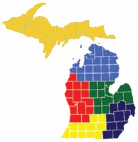
| List of Counties, by Region | |||||
| Upper Peninsula | Northern Lower Peninsula | West Central | East Central | Southwest | Southeast |
| Alger Baraga Chippewa Delta Dickinson Gogebic Houghton Iron Keweenaw Luce Mackinac Marquette Menominee Ontonagon Schoolcraft |
Alcona Alpena Antrim Benzie Charlevoix Cheboygan Crawford Emmet Grand Traverse Iosco Kalkaska Leelanau Missaukee Montmorency Ogemaw Oscoda Otsego Presque Isle Roscommon Wexford |
Allegan Barry Ionia Kent Lake Manistee Mason Mecosta Montcalm Muskegon Newaygo Oceana Osceola Ottawa |
Arenac Bay Clare Clinton Gladwin Gratiot Huron Isabella Midland Saginaw Sanilac Shiawassee Tuscola |
Berrien Branch Calhoun Cass Eaton Hillsdale Ingham Jackson Kalamazoo St. Joseph Van Buren |
Genesee Lapeer Lenawee Livingston Macomb Monroe Oakland St. Clair Washtenaw Wayne |